Albania

Albania is a country in Southeastern Europe. It is bordered by Montenegro to the northwest, Kosovo to the northeast, Macedonia to the east, and Greece to the south and southeast. It has a coast on the Adriatic Sea to the west and on the Ionian Sea to the southwest. It is less than 72 km (45 mi) from Italy, across the Strait of Otranto which links the Adriatic Sea to the Ionian Sea.


Albania is a member of the UN, NATO, the Organization for Security and Co-operation in Europe, Council of Europe, World Trade Organisation, and is one of the founding members of the Union for the Mediterranean. Albania has been a potential candidate for accession to the European Union since January 2003 and it formally applied for EU membership on 28 April 2009.


The modern-day territory of Albania was at various points in history part of the Roman provinces of Dalmatia (southern Illyricum), Macedonia (particularly Epirus Nova), and Moesia Superior. The modern Republic became independent after the collapse of the Ottoman Empire in Europe following the Balkan Wars. Albania declared independence in 1912 (to be recognised in 1913), becoming a Principality, Republic, and Kingdom until being invaded by Italy in 1939, which formed Greater Albania, which in turn became a Nazi protectorate in 1943. In 1944, a socialist People’s Republic was established under the leadership of Enver Hoxha and the Party of Labour. In 1991, the Socialist Republic was dissolved and the Republic of Albania was established.

Origins and the Middle Ages

The Albanians are considered descendants of ancient Illyrian or Thracian tribes of Indo-European origin that may have come to the Balkan Peninsula even before the Greeks.Albanopolis city was mentioned in the 2nd century BC by Ptolemy in his Geography. Later, while nominally under Byzantine rule, Albania was raided by Slav invaders in the 6th century and was annexed to Bulgaria in the 9th century.


From the Ottomans to Independence

Turkish advances, which began in 1388, were resisted from 1443 to 1468 by Gjergj Kastrioti, better known as Scanderbeg, the Albanian national hero, but by 1479 the Turks attained complete control of the area. In November 1912, during the First Balkan War, the National Assembly convened in Vlorë under the chairmanship of Ismail Kemali and proclaimed Albania’s independence. Following a period of unstable parliamentary government (1921–24), Ahmet Zogu, the chief of the Mat district, seized power with Yugoslav support. He proclaimed Albania a republic in 1925, with himself as president, and a kingdom in 1928, with himself as King Zog I.


Under Communist Rule

Relations with Communist countries other than China worsened during the 1960s, as Albania ceased to participate in the activities of the Warsaw Treaty Organization by September 1968 following the Soviet invasion of Czechoslovakia. On 28 December 1976, Albania adopted a new constitution that formally established Marxism-Leninism as the dominant ideology and proclaimed the principle of self-reliance. Internally, Albania seemed to be locked in bitter political conflict as the 1980s began. Prime Minister Mehmet Shehu, relieved of his defense portfolio in April 1980, died in December 1981, an alleged suicide. A year later, Hoxha charged that Shehu had been working for the US, Soviet, and Yugoslav secret services and that Shehu even had orders from Yugoslavia to kill him. Hoxha died on 11 April 1985 and was succeeded as first secretary of the Workers Party by Ramiz Alia, who had been chairman of the presidium of the People’s Assembly since 1982. In the mid-1980s, Albania took steps to end its isolation.


Democracy and a Free-Market Economy

President Berisha and his Democratic Party pushed hard for radical reforms to create a market economy and democratic institutions internally, while bringing Albania back into the international mainstream after half a century of isolation.

Albania’s food is based very heavily on meat- particularly lamb and beef- and cooked in a typically Middle Eastern style. The main influence of Albanian cuisine is that of Turkey- among the most common dishes in Albania are romsteak (patties made of minced meat), qofte (meat balls) and shishqebap (sheesh kababs). A number of other meat-based dishes are also popular; these include rosto me salcë kosi (roast beef with sour cream), fërges (beef stew), and çonlek (a meat stew with onions). The country grows a lot of olives, citrus fruits and grapes, and all appear prominently in local menus. The country produces, like every other Mediterranean land, lots of wine- white and reds, the former’s usually better than the latter; in addition, there are fruit liqueurs of different types, uzo – an aniseed-flavoured liqueur, and brandies locally called konjak and raki. Albania is also known for its coffee- the strong kafe turke and the milder kafe ekspres (espresso).

Berat County

National Ethnographic Museum is a museum in Berat, Albania. It opened in 1979 and contains a diversity of everyday objects from throughout Berat’s history. Themuseum contains original furniture and a number of household objects, wooden case, wall-closets, as well as chimneys and a well. Near the well is an olive press, wool press and many large ceramic dishes, revealing a glimpse of the historical domestic culture of Berat’s citizens. The ground floor has a hall with a model of a medieval street with traditional shops on both sides and on the second floor is an archive, loom, village sitting room, kitchen and sitting room.


Durrës County

Archaeological Museum in Durrës, Albania, established in 1951, is the largest archaeological museum in the country. The museum is located near the beach and north of the museum are the 6th-century Byzantine walls, constructed after the Visigoth invasion of 481. The 1997 rebellion in Albania saw the museum seriously damaged and looted. The bulk of the museum consists of artifacts found in the nearby ancient site of Dyrrhachium and includes an extensive collection from the Ancient Greek, Hellenistic and Roman periods. Items of major note include Roman funeral steles and stone sarcophagi, an elliptical colourful mosaic measuring 17 by 10 feet, referred to as The Beauty of Durrës, and a collection of miniature busts of Venus, testament to the time when Durrës was a centre of worship of the goddess.Ethnographic Museum (House of Aleksandër Moisiu).


Kruja County

Skanderbeg Museum is in Krujë, Albania. It honors George Kastrioti Skanderbeg (1405–1466), a national hero of Albania. The museum is located inside Krujë Castle and the restored bazaar. The citadel includes a restored house from the Ottoman era that is now the Ethnographic Museum.


Tirana County

The National Historical Museum includes the following pavilions: Antiquity, Medieval, Rilindja Kombetare, Iconography, Culture of Albania, Albanian Resistance of World War II, and Communist genocide.National Historical Museum of Albania is the country’s largest museum. It was opened on 28 October 1981 and is 27,000 square metres in size, while 18,000 square metres are available for expositions. The museum was designed by Albanian architect Enver Faja. The construction of the museum required the demolition of the former Tirana Municipal Building. The gigantic mosaic appearing at the main entrance is entitled The Albanians.National Archaeological Museum is a national archaeological museum in Tirana, Albania. Affiliated to Institute of Archaeology of the Academy of Sciences of Albania, the museum houses exhibits from prehistoric and historic times up to Middle Ages. It is also responsible for conducting many archaeological expeditions in the country and is the parent institution of several other museums in the country including the Durrës Archaeological Museum. It has a library of some 7200 volumes.Natural Sciences Museum of Albania is a natural science museum in Tirana, Albania. The museum is affiliated with the University of Tirana and has branches in zoology botanyand geology.


Fieri County

Museum of Apollonia is an archaeological museum approximately 8 km (5.0 mi) west of Fier, Albania. It was established in 1958. The museum contains artifacts unearthed nearby from the ancient Greek town of Apollonia and is close to the Ardenica Monastery.Congress of Lushnjë Museum is a museum in Lushnjë, Albania. The Congress of Lushnjë was held here in 1920. In 1970 the building was turned into a museum devoted to patriotism. It contains numerous photographs and original documents related to Albania’s struggle against Fascism. The white building has 5 bays on the middle floor and 2 bays on the top floor.


Gjirokastër County

Ethnographic Museum is a museum in western Gjirokastër, Albania. The museum is erected on the site of communist dictator Enver Hoxha’s birth, and offers an insight into the traditional lifestyle in the town.


Korça County

National Archaeological Museum of Korçë is a museum in Korçë, Albania. It contains around 1200 artifacts from the Hellenic period.Bratko Museum is a museum in Korçë, Albania. It contains a collection of mostly Asian art.National Museum of Medieval Art is a museum in Korçë, Albania. It was established on April 24, 1980. The museum has over 7,000 art and cultural items, mainly icons and less stone, wooden, metal and textile works representing various moments in Albania iconography development. In the principal hall are many works from anonymous artists of the 13th-14th century and well-known ones such as Onufri, Onufer Qiprioti, Teacher Kostandini, Jeromak Shpataraku, David Selenica, the Zografi Brothers, etc.

Butrint

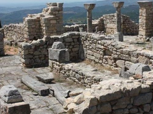
Butrint is perhaps the most romantic archaeological site in Albania. Inhabited since prehistoric times, Butrint has been a Roman city and a bishopric. Following a period of prosperity under Byzantine administration, then a brief occupation by the Venetians, the city was abandoned in the late middle Ages after marshes formed in the area. The present archaeological site is a repository of ruins representing each period in the city’s development.


WHAT TO VISIT…

  • Tample of Aesculapius
  • The Baptisery
  • Nymoheum
  • Gate with towers


Apollonia

Situated 12 km from the city of Fier. Illyrian Apollonian was found at the beginning of the 7th century BC by the Greek colonists coming from Corinth and Corcyra. Apollonian was in Roman times, a large and flourishing city near Aos river (today Vjosa). Of great interest to be visited are; The Encircling Wall, the monuments of Agonothetes, the Library, the Odeon, the Portico, the house with mosaics, The Museum of Apollonia, the Church of St. Mary. Unfortunaly, some of the statues and object were appropriated before 1946 by other countries. Those remaining are displayed in the museum, which is housed in the monastery. The monastery courtyard enclosed a Byzantine church dating back to the 14th century.


WHAT TO VISIT…

  • The museum of Apollonia
  • The excavations of Apollonia
  • The monuments of Apollonia
  • The encircling wall
  • The tarraced wall with the arched gates
  • The monument of Agonothetes
  • The library and the Odeon
  • The porticoThe house with mosaics
  • The churche of St. Maru


Bylis

Bylis (in today Mallakastra) which is a very important archeological center in Albania, is one of ancient Illyrian citys inhabited by the tribe of Bylliones. Established in the third century B.C., Bylis flourished as a political, economic, and cultural center of the community. The city was governed by an annual council of civil servants. In 230-146 B.C., it introduced bronze coins, which were used throughout this region. The handicrafts from the workshops of Bylis were competing with the handicrafts of Apollonia. The surrounding wall of Bylis, built in the second quarter of the fourth century B.C., is very well-preserved. It is 2250 m long, 3.5 m wide and 8-9 m high and it surrounds an area of 30 ha. The wall is triangular. The city consisted of several quarters and objects, such as the agora, which sheltered the inhabitants of the villages and their wealth in the event of war. It is very interesting to see:

The theatre, which is larger than that of Butrint and was built in the middle of the third century B.C.
The monumental fountain of the 3rd century. – Several stadium elements. – Medieval cultural objects such as Basilica
In the Church of Bylis which was build on the IV th century AD, the mosaics have Ilirian (Illyrian) motifs which for the church later where known as pagan ones.


Antigonea

Antigonea was founded on the order of King Pyrrhus 318 – 272 BC, the greatest of the kings of ancient Epirusi. He named it in honor of his wife, Antigone, the step daughter of King Ptolemy of Egypt, one of the generals of Alexander the Great. Antigonea was a model Hellenistic style city, with a circuit of stone-built walls, 4 km long, a fortified acropolis at the highest northern end, and a regular street pattern laid out along the ridge. The city was equipped with paved roads and drains, public spaces, an agora overlooking the valley to the west, and temples and other public buildings. An inscription speaks of the presence of a gymnasium in the city. Houses with courtyards lined the street. Antigonea was a city dependent on the agriculture of the area. Trade was also important with fine black glazed table wares being imported from Greece, and amphorae from as far afield as Rhodes. There is also evidence of weaving and metalworking. Fragments of a bronze equestrian statue, perhaps of Pyrrhus himself, were found during excavations in the agora. The coins recovered are from a mixture of Illyrian and Greek cities and Antigonea was undoubtedly an important crossroads between the north and the south.


Amantia

Amantia was an ancient Greek polis in Epirus. It occupied an important defensive position above the Aoos river valley to the east, and on the road to the coast and the Bay of Vlorë. A Greek temple, the Aphrodite temple, a theatre, and a stadium have also been found in the city. The name for its civilians was Amantieus.


Dropull

Dropull is a predominantly Greek-inhabited region in Gjirokastër District, in southern Albania. The region stretches from south of the city of Gjirokastër to the Greek–Albanian border, along the Drinos river. The region’s villages are part of the Greek “minority zone” recognized by the Albanian government, in which live majorities of ethnic Greeks. Dropull is divided into two municipalities: Upper Dropull and Lower Dropull.


Lezhe

Lezhë, Albanian pronunciation is a city in northwest tAlbania, in the district and county with the same name. It is located at 41.79°N 19.65°E and has a population of about 27,500 (2009 est). In ancient history it was an ancient Greek colony named Lissus. The latter is an Archaeological Park of Albania.


Oricum

Oricum was an ancient Greek city in the northern part of Epirus (modern south Albania), at the south end of the Bay of Vlorë. The city is an Archaeological Park of Albania.


Phoenice

Phoenice or Phoenike was an ancient Greek city in Epirus and capital of the Chaonians. It was also the location of the Treaty of Phoenice which ended the First Macedonian War, as well as one of the wealthiest cities in Epirus until the Roman conquest. During the early Byzantine period, Phoenice was the see of a bishopric. The city is an archaeological park of Albania and is located on a hill above a modern town which bears the same name, Finiq, in modern southern Albania.


Rozafa Castle

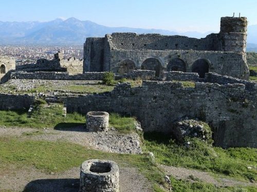
Rozafa castle is a castle near the city of Shkodër, in northwestern Albania. It rises imposingly on a rocky hill, 130 metres above sea level, surrounded by the Bojana and Drin rivers. Shkodër is the capital of the District of Shkodër, and is one of Albania’s oldest and most historic towns, as well as an important cultural and economic centre.Due to its strategic location, the hill has been settled since antiquity. It was an Illyrian stronghold until it was captured by the Romans in 167 BC. The 19th-century German author and explorer Johann Georg von Hahn suggested that the ancient and medieval city of Shkodër was located immediately south of the Rozafa hill, between the hill and the confluence of Bojana and Drin. The fortifications, as they have been preserved to date, are mostly of Venetian origin. The castle has been the site of several famous sieges, including the siege of Shkodra by the Ottomans in 1478 and the siege of Shkodra by the Montenegrins in 1912. The castle and its surroundings form an Archaeological Park of Albania.

Butrint

Butrint was an ancient Greek and later Roman city in Epirus. In modern times it is an archeological site in Sarandë District, Albania, some 14 kilometres south of Sarandë and close to the Greek border. It was known in antiquity as Bouthrōtios in Ancient Greek and Buthrotum in Latin. It is located on a hill overlooking the Vivari Channel and part of theButrint National Park. Inhabited since prehistoric times, Buthrotum was a city of the Greek tribe of the Chaonians, later a Roman colony and a bishopric. It entered into decline in Late Antiquity, before being abandoned during the Middle Ages after a major earthquake flooded most of the city.


Dajt Mount

Dajt Mount is a mountain in central Albania, to the east of Tirana. Its highest peak is at 1,613 m (5,292 ft). In winter, the mountain is often covered with snow, and it is a popular retreat to the local population of Tirana that rarely sees snow falls. Its slopes have forests of pines, oak and beech. Dajt Mountain declared “National Park” is today an area of about 3333 ha. It is under the jurisdiction and administration of Tirana Forest Service Department.


Karavasta

The Karavasta Lagoon is the largest lagoon in Albania and one of the largest in theMediterranean Sea. It is separated from the Adriatic Sea by a large strip of sand. The lagoon is part of the Divjake-Karavasta National Park. It was elected as an area of international importance, protected by the Ramsar Convention of 29 November 1995.


Lura

Lura is a park located in Lurë municipality in north-eastern part of Albania. It includes Kunora e Lurës which reaches a height of 2,119 m (6,952 ft) above sea level, the highest peak of Lurë Mountains.The most common type of tree is the Beech which is found on altitudes between 900 and 1,000 m (2,953 and 3,281 ft) to 1,900 and 2,000 m (6,234 and 6,562 ft). On altitudes between 1,600 and 1,700 m (5,249 and 5,577 ft) Black Pine[disambiguation needed] are abundant and on altitudes between 1,700 and 2,000 m (5,577 and 6,562 ft) separate Red Pineand White Pine[disambiguation needed] are found on rocky slopes. These forests are home to the rare European Brown Bear,Eurasian Lynx, Eurasian wolf, European Pine Marten, Roe Deer and Capercaillie.A prime attraction for visitors to Lurë National Park and its mountains is its many lakes. The mountain range contains twelveglacial lakes which were formed during the Würm glacial period. These 12 lakes are home to the Smooth Newt and the Great Crested Newt. These lakes are found between 1,200 and 1,500 m (3,937 and 4,921 ft).


Llogora

Llogora is a national park in Albania declared since 1966 by the Albanian Government. The park covers an area of 1,010 hectares (2,500 acres) and protects the forests on the north side of the Llogara Pass between a height from 470 to 2,018 m (1,540 to 6,621 ft) above sea level. In the park can be found many black pine (Pinus nigra) trees, Bosnian Pines (Pinus heldreichii), Bulgarian fir, (Abies borisii-sign) andash trees (Fraxinus).Air currents around the area have caused trees to bend in many interesting shapes, like the Pisha e Flamurit.


Prespa

Prespa is the name of two freshwater lakes in southeast Europe, shared by Albania, Greece, and the Republic of Macedonia. Of the total surface area, 176.3 km2 (68.07 sq mi) belongs to the Republic of Macedonia, 46.3 km2 (17.88 sq mi) to Albania and 36.4 km2(14.05 sq mi) to Greece. They are the highest tectonic lakes in the Balkans, standing at an altitude of 853 m (2,798 ft).138 km2 (53.28 sq mi) drainage area; 42.5 km2(16.41 sq mi) surface area) and Albania (51 km2 (19.69 sq mi) drainage area; 4.3 km2 (1.66 sq mi) surface area).


Thethi

Theth is a national park in extreme northern Albania declared by government decree in 1966. It covers an area of 2,630 hectares and is located along the Theth River. The main attractions in the park are the Grunas Waterfall and the Lock-in Tower. Theth is adjacent to it and was declared a national park in 1966. It is proposed that the two parks, along with the areas in Montenegro andKosovo form a tri-border Bjeshket e Nemuna National Park.


Tomorr

Tomorr is a large mountain in southern Albania. Its highest peak, called Çuka e Partizanit, reaches a height of 2,416 m (7,927 ft). It is located east of the towns of Berat and Poliçan and the river Osum not far from the Canyon of Osum river.In antiquity the region of Tomorr (Greek: Άμυρον Amyron) was inhabited by the Dexari, a tribe of Epirus that belonged to theChaonian group of the northwestern Greeks.Albanian folklore tells how Tomorr came to be. The people believed that Tomorr was a giant that wanted to fight another giant named Shpirag for a young woman. The two giants killed each other and when hearing this the young woman cried and drowned in her own tears thus creating the river of Osum.Tomorr is of great spiritual importance to the local people. On the summit of the mountain a Bektashi shrine to the brother ofImam Husain, Abbas ibn Ali can be found. Each August thousands of faithful make pilgrimage to this shrine.Tomorr also offers many sports facilities such as skiing. For its importance and beauty the Albanian Government declared Tomorr a National Park. Tomorr Mountain National Park (Albanian:Parku Kombëtar i Malit të Tomorrit) covers an area of 4,000 hectares. Many endangered species are free to roam and live there.


Valbona

Valbona is adjacent to it and was declared a national park in 1996. is a national park in Albania declared by government decree in 1996. It covers an area of 8,000 hectares and is located along the Valbona Valley. A main attraction is the Valbona River flowing in the middle of the valley.Some attractions of the park include: Valbona Pass at 1811 meters of altitude, Cave of the Wind at 1942m, Zhapore Trail at 1624m, Beautiful alcoves at 1742m, Curraj i Eperm Church, Snow Cave.


Fir of Hotova

Fir of Hotova is a national park in southern Albania, in the region of Frashër, 35 km north-east of Përmet. The park has an area of 1,200 hectares. It takes its name from the Hotova Fir which is considered one of the most important Mediterranean plant relics of the country.


Qafë Shtama

Qafë-Shtama resides in the edge mountains Albania’s north ofTirana, about 25 kilometers east of Kruja. It is named after the Qafë-Shtamë passage. It has an area of 2000 acres, with a beautiful mountain scenery, some small lakes and major sources consisting mainly of pine forests. The national park was founded in 1996. It is becoming lately a popular attraction for hiking.The park’s name translates as pass Shtama. The road from Kruja to Burrel, runs through the park, on an altitude about 1250 meters.North of the pass road, the majority of the park is mostly undeveloped mountain land with forests, in which pine trees, and oak dominate. The black pines are up to 20 meters high and 60 years old – one of the main wood sources in Albania. The forests provide opportunities for retreat for brown bears, wolves,foxes, and various birds, actually being endangered from illegal deforestation. The highest points on which it rises steeply from the Pass to the north, are the Maja e Liqenit (1724 meters) and the off peak Maja i Rjepat e Qetkolës ( 1686 meters). Maja e Liqenit should not be confused with the peak with the same name in Sharr region of Kosovo. In the south of the park is adjacent to the Dajti National Park.The most significant source of water is called Kroi i Nenës Mbretëreshë (English:Source of the Queen Mother), known for its clean, clear and healthy water. The legend refers to the Albanian Royal Family, allegedly daily supply from this water source would be after of a laboratory in Vienna had awarded it as the best water in the country in 1932 by performing laboratory tests. The word Queen Mother probably points at Sadije Toptani, the mother of Ahmet Zogu, or Geraldine Apponyis, his wife, who had first visited Albania in 1937. Nena Mbretëreshë is a common name for the king’s mother. King Zog, was born in Mat region, originating from the east side of the pass. He is said to have also build a recreation villa in the area.The water is also collected and taken to a bottling plant, residing a little further down from the park entrance. The produced bottled mineral water is sold nationwide under the brand Qafshtama.On 29 April 1997, an underground bunker complex on the east side of the pass was house of a serious accident. An explosion would take place in the tunnels full of ammunition and weapons, stored in a military storage site during thecommunist era, which were dismantled in the 1990s. As a result of the collapse of public order, several people tried to disassemble metals for selling it, without applying any care or having proper military knowledge. As a result, there was an explosion in the tunnel. 23 people were killed, including many young people from a nearby village of Selishtë.


Shebenik

Shebenik is a protected national park located in the northeastern part of the Librazhd District,Elbasan County in central Albania. The park covers an area of 33,927.7 hectares and shares a border with the Republic of Macedonia. Elevations in the park vary from 300m to over 2,200m at the peak of Shebenik mountain, which, along withJablanica give name to the park. The park is one of Albania’s newest, created in 2008. Within the park region dwell a number of different species that are fast becoming rare in Albania, including the brown bear, gray wolf and the endangered Balkan Lynx. Further, the park is home to a number of endemic and rare plants. The nearest towns to the park are Librazhd andPrrenjas.On 21 April 2011, the PPNEA (Protection and Preservation of Natural Environment in Albania) research team got the first photo of an alive Balkan lynx living within the boundaries of the national park.


Karaburun – Sazan

Karaburun – Sazan proclaimed in 2010 is the only nationalmarine park of Albania. The park covers a marine area stretching 1-nautical-mile (1.9 km) along the coastlines of Karaburun Peninsulaand Sazan Island near the Bay of Vlora. The marine park is 16 kilometres (9.9 mi) long with a width varying from 3 to 4.5 kilometres (1.9 to 2.8 mi), and covering 12428 ha of surface in total. Karaburun Peninsula itself is a Managed Nature Reserve while Sazan Island is a military zone in Albania.


Korab

Korab is the highest mountainof Albania and the Republic of Macedonia, its peak forming a frontier between the two countries. The peak lies adjacent to theŠar Mountains. In 2011, Albania proclaimed the area as part of the Korab-Koritnik Natural Park.Mount Korab is also pictured in the coat of arms of the Republic of Macedonia.